


Hurricane Lee remained a powerful high-end Category 4 storm on Friday, weakening only slightly from its peak as a scale-topping storm the night before.
Forecasters expect Lee to maintain its tremendous strength through early next week. The storm will begin to turn north next week, encountering a complex steering pattern where small changes will have a huge effect on the storm’s eventual path.
Anyone across Atlantic Canada and New England should closely monitor Hurricane Lee’s developments through the weekend.
Visit The Weather Network’s hurricane hub to keep up with the latest on tropical developments in Canada and around the world
Lee rapidly intensified into a scale-topping Category 5 hurricane on Thursday night, peaking with maximum sustained winds of 270 km/h at 5:00 a.m. on Friday.
The hurricane underwent one of the most remarkable bouts of rapid intensification ever recorded in the Atlantic basin, during which its winds jumped 140 km/h in just 24 hours.
DON’T MISS: A world first, every tropical ocean saw a Category 5 storm in 2023
The storm has since weakened slightly from its pinnacle strength, but it remains a dangerous Category 4 storm with sustained winds of 240 km/h on Friday evening.
Forecasters expect Hurricane Lee to persist as an intense major hurricane for the next five days as it steadily moves west-northwest, staying far north of the Antilles.
While the storm won’t directly affect land through early next week, rough surf and dangerous rip currents are expected on beaches across the Caribbean, Bermuda, and the U.S. East Coast beginning this weekend.
WATCH: The best time to prepare for a hurricane is long before one threatens. Here’s how
Click here to view the video
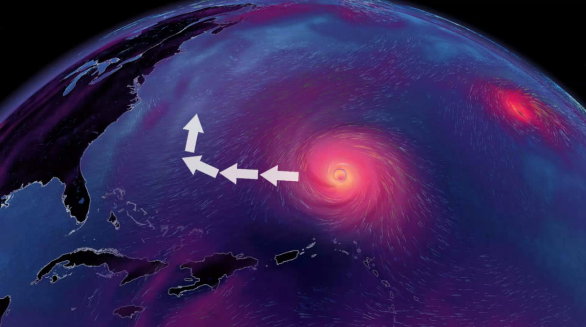
Uncertainty surrounds Lee’s northward turn and eventual path
It’s still too soon to predict how and if this hurricane will directly affect parts of the eastern seaboards of the United States and Canada in the next seven days.
MUST SEE: How a mammoth hurricane rapidly intensifies in mere hours
There are lots of dynamic features that will affect Lee’s eventual path, and small changes will have a large impact on where it goes. It’s also important to note that Lee would not be at its peak strength if it affects land late next week.
We’re keeping an eye on two major features that will be critical in determining where Lee tracks next week.
A centre of high pressure over the central Atlantic Ocean is responsible for steering Hurricane Lee toward the west right now. Most computer models see this ridge of high pressure weakening by the middle of next week, allowing Lee to slow down or potentially even stall as it reaches the southwestern Atlantic Ocean.
DON’T MISS: How hot water fuels the world’s most powerful hurricanes
Meanwhile, a sharp trough swooping over the eastern United States will likely begin steering Lee toward the north.
The precise timing of this atmospheric tango will determine Lee’s track as we head through the latter half of next week into the following weekend.
Individual factors like the strength of the ridges and troughs, as well as Lee’s own strength and position, will have a significant effect on the hurricane’s path. These factors are too delicate to predict with any certainty almost a week in advance.
Forecasters will have a clearer picture of the winds responsible for steering Hurricane Lee as we head through the weekend.
Stay prepared
We’re now in the climatological peak of hurricane season across the Atlantic basin. Anyone along or near the East Coast should prepare for hazards like power outages and flooding regardless of this one storm’s progress.
Ensure you’ve got non-perishable food, water, personal hygiene supplies, flashlights, and batteries to last for several days without electricity or water. Prepare an emergency plan in case of flooding or evacuations.
STAY SAFE: What you need in your hurricane preparedness kit
Anxiety is normal when there’s a big storm out there, and even more so when the storm’s future is uncertain. Preparing for a storm now—long before one ever draws near—ensures you’ll be ready to go if anything looms on the horizon in the weeks and months ahead.
Stay with The Weather Network for the duration of this storm as we closely monitor this hurricane and its developments.
Header satellite image courtesy of NOAA.
WATCH: 2023 has seen a category 5 hurricane in every corner of the tropics
Click here to view the video
Read the full article here


